background image

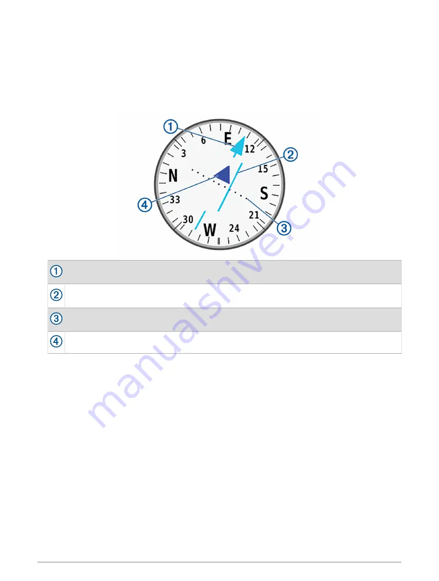
Using the Course Pointer

The course pointer is most useful when you are navigating to your destination in a straight line, such as when 
you are navigating on water. It can help you navigate back to the course line when you go off-course to avoid 
obstacles or hazards.
Press PAGE to scroll to the compass page. 
Press MENU.
Select Heading Setup > Go To Line (Pointer) > Course (CDI) to enable the course pointer.

Course line pointer. Indicates the direction of the desired course line from your starting point to your 
next waypoint.

Course deviation indicator (CDI). Indicates the location of the desired course line in relation to your 
location. If the CDI is aligned with the course line pointer, you are on course.

Course deviation distance. The dots indicate your distance off course. The distance represented by 
each dot is indicated by the scale in the upper-right corner.

To-and-from indicator. Indicates whether you are headed to or away from the next waypoint.

Navigating with Sight 'N Go

You can point the device at an object in the distance with the compass direction locked in, project the object as 
a waypoint, and navigate using the object as a reference point.
Press PAGE to scroll to the compass page. 
Press MENU.
Select Sight 'N Go.
Point the device at an object.
Select Lock Direction > Set Course.
Navigate using the compass.

14

Using the Main Pages

Summary of Contents for GPSMAP 67i

Page 1: ...GARMIN GPSMAP 67i Quick Start Manual 2 Manuel de demarrage rapide 15 Manuale di avvio rapido 30 Schnellstartanleitung 44 Gufa de inicio rapido 59 Manual de infcio rapido 74...

Page 2: ...in the product box for product warnings and other important information Device Overview c nQt5 0 0 CD Internal Iridium and GNSS antenna Power button SOS button 2 Buttons USB port under weather cap Fl...

Page 3: ...n pages Press to open the options menu for the page that is MENU currently open Press twice to open the main menu from any page PAGE Press to scroll through the main pages Press to select menu options...

Page 4: ...isplay to customize the backlight and battery save settings PairingYour Phone and Activating the Device lf S WAANING Before you can use the inReach features of your device including messaging SOS trac...

Page 5: ...ing a wireless connection or cellular data on your phone Quick Start Manual do not incur data charges or additional I charges on your inReach subscription Messages received may incur charges if messag...

Page 6: ...intended to be used Messages Your GPSMAP 67i device sends and receives text messages using the Iridium satellite network 6 Sending aText Message 1 From the Messages page select New Message 2 Select a...

Page 7: ...them over the Iridium satellite network at the specified send interval Track points appear on the Garmin Explore website and the MapShare tracking page Quick Start Manual Starting Tracking From the m...

Page 8: ...ce with details about your location 4 Reply to the confirmation message from the emergency response service Your reply lets the emergency response service know that you are capable of interacting with...

Page 9: ...the app Quick Start Manual Connected Features I Connected features are available for your GPSMAP 67i device when you connect the device to awireless network or a compatible phone using Bluetooth techn...

Page 10: ...Explore account Phone notifications Displays phone notifications and messages on your GPSMAP 67i device using the Garmin Explore app 10 Software Updates Allows you to receive updates for your device s...

Page 11: ...evation and depth menu Creating aWaypoint 2 Select Route Planner Create Route You can save your current location as a Select First Point waypoint 3 Select a category 1 Select MARK 4 Select the first p...

Page 12: ...ess MENU twice to open the main menu 2 Select Recorded Activities 3 Select an activity 12 4 Select n 5 Select Go Map Arepresents your location on the map As you travel Amoves and displays your path De...

Page 13: ...ll Garmin Express www garmin com express On your phone install the Garmin Explore app This provides easy access to these services for Garmin devices Quick Start Manual Software updates Map updates Dat...

Page 14: ...a Memory Card You can install a microSD memory card up to 32 GB for additional storage or pre loaded maps 1 Lift the weather cap on the side of the device CD 14 C E E ld r 1 r 1 7 2 Insert the memory...

Page 15: ...ss permission of Garmin The BLUETOOTH word mark and logos are owned by the Bluetooth SIG Inc and any use of such marks by Garmin 1s under license Iridium is a registered trademark of Iridium Satellite...

Page 16: ...GPSMAP 67i Owner sManual...

Page 17: ...HuntView Garmin Messenger Garmin Response SM MapShare and tempe are trademarks of Garmin Ltd or its subsidiaries These trademarks may not be used without the express permission of Garmin Android is a...

Page 18: ...SOS Rescue 10 Sending a Custom SOS Message 10 Canceling an SOS Request 10 Sending a Test Message 11 Syncing inReach Data 11 Contacts 11 Adding a Contact 11 Editing a Contact 11 Deleting a Contact 11 U...

Page 19: ...Saved Activity 25 Deleting a Saved Activity 26 Courses 26 Creating a Course 26 Creating a Course Using the Map 26 Navigating a Saved Course 26 Editing a Course 27 Editing the Name of a Course 27 Viewi...

Page 20: ...Sending and Receiving Data Wirelessly 42 Using the VIRB Remote 42 Customizing the Device 42 Customizing the Data Fields 42 Setup Menu 43 System Settings 43 Satellite Settings 43 Display Settings 44 Tu...

Page 21: ...4 Viewing E label Regulatory and Compliance Information 54 Appendix 55 Data Fields 55 Optional Accessories 57 tempe 57 Tips for Pairing Wireless Sensors 58 Troubleshooting 58 Maximizing Battery Life 5...

Page 22: ...on guide in the product box for product warnings and other important information Device Overview Internal Iridium and GNSS antenna Power button SOS button Buttons USB port under weather cap Flashlight...

Page 23: ...each message failed to send The device is below 10 percent battery power Alternating red and green flashes The device is in SOS mode Status Icons ANT sensor status GPS signal strength Charging battery...

Page 24: ...es MENU Press to open the options menu for the page that is currently open Press twice to open the main menu from any page PAGE Press to scroll through the main pages Press to select menu options and...

Page 25: ...rts recording your path as an activity GPS and Other Satellite Systems Using GPS and another satellite system together offers increased performance in challenging environments and faster position acqu...

Page 26: ...and the battery gauge appears 3 Charge the device completely Pairing Your Phone and Activating the Device WARNING Before you can use the inReach features of your device including messaging SOS trackin...

Page 27: ...ts and collections plan trips and use cloud storage They offer advanced planning both online and offline allowing you to share and sync data with your compatible Garmin device You can use the app to d...

Page 28: ...urn on caps lock select PAGE twice To insert a backspace select To insert a space select Replying to a Message 1 Press MENU twice to open the main menu 2 Select Messages 3 Select a conversation 4 Sele...

Page 29: ...not support viewing maps or is outside of a mobile data coverage area and cannot view a web page 1 Press MENU twice to open the main menu 2 Select Messages New Message Send Location 3 Enter one or mo...

Page 30: ...g Moving Interval Sets the frequency at which the navigator records a track point and transmits it over the satellite network when you are moving If you are on a professional plan you can specify the...

Page 31: ...itiate an SOS rescue and interact with the Garmin Response team using the Garmin Messenger app You must have an active satellite subscription to use the SOS feature in the app Sending a Custom SOS Mes...

Page 32: ...the connection status on the Device tab in the app Contacts You can add delete and edit contacts on the GPSMAP 67i device Adding a Contact 1 Press MENU twice to open the main menu 2 Select Setup Conta...

Page 33: ...ress and To view more information about a waypoint on the map represented by an icon or other location move the map cursor to the location and press ENTER Measuring Distance on the Map You can measure...

Page 34: ...age and press MENU Select Map Setup Advanced Setup Auto Zoom Automatically selects the appropriate zoom level for optimal use on your map When Off is selected you must zoom in or out manually Detail S...

Page 35: ...on of the desired course line in relation to your location If the CDI is aligned with the course line pointer you are on course Course deviation distance The dots indicate your distance off course The...

Page 36: ...oard NOTE Your customized settings are remembered by the dashboard Your settings are not lost when you change profiles Profiles page 49 Set Scale Sets the scale for the distance between the dots on th...

Page 37: ...as the heading reference select Grid To set the magnetic variation value manually select User enter the magnetic variance and select Done Trip Computer The trip computer displays your current speed av...

Page 38: ...me Calibrate Altimeter Allows you to manually calibrate the barometric altimeter Calibrating the Barometric Altimeter page 17 Calibrating the Barometric Altimeter You can manually calibrate the barome...

Page 39: ...you are going or where you have been You can add details about the location such as name elevation and depth You can add a gpx file that contains waypoints by transferring the file to the GPX folder T...

Page 40: ...to open the main menu 2 Select Waypoint Manager 3 Select a waypoint 4 Press MENU 5 Select Delete Changing the Photo for a Waypoint 1 Press MENU twice to open the main menu 2 Select Waypoint Manager 3...

Page 41: ...elect Move Waypoint 6 Press or to move the cursor to a new location on the map 7 Select Move Finding a Location Near a Waypoint 1 Press MENU twice to open the main menu 2 Select Waypoint Manager 3 Sel...

Page 42: ...ice Creating a Route Using Route Planner A route can include many waypoints and it should include at least a starting point and one destination 1 Press MENU twice to open the main menu 2 Select Route...

Page 43: ...t Remove 8 Select QUIT to save the route Editing the Name of a Route You can customize the name of a route to make it distinct 1 Press MENU twice to open the main menu 2 Select Route Planner 3 Select...

Page 44: ...ng your path when you are not moving Auto Start Sets the device to start a new recording automatically when the previous recording ends Activity Type Sets the default activity type for the device Adva...

Page 45: ...s retain all of their original track points Viewing the Current Activity By default the device automatically starts recording your path as an activity when it is turned on and has acquired satellite s...

Page 46: ...a location An information bar appears at the top of the screen 6 Press ENTER 7 Press MENU 8 Select Save as Waypoint Creating a Track from a Saved Activity You can create a track from a saved activity...

Page 47: ...ect First Point 5 Select a category 6 Select the first point in the course 7 Select Use 8 Select Select Next Point to add additional points to the course 9 Select Done Creating a Course Using the Map...

Page 48: ...ve the point from the course select Remove 8 Select QUIT to save the course Editing the Name of a Course You can customize the name of a course to make it distinct 1 Press MENU twice to open the main...

Page 49: ...open the main menu 2 Select Course Planner 3 Select a course 4 Press MENU 5 Select Delete Optional Maps You can use additional maps with the device such as Outdoor Maps City Navigator and Garmin Hunt...

Page 50: ...Provides paid or subscription free services to view live geocache data from www geocaching com using the Garmin Explore app or when connected to a Wi Fi network Tracking Allows you to record track poi...

Page 51: ...main menu 2 Select Setup Wi Fi 3 Select the toggle switch to enable Wi Fi technology if necessary 4 Select Add Network 5 Select a wireless network from the list and enter the password if necessary The...

Page 52: ...dgets Data Use and History You can view plan details and data use on the GPSMAP 67i device Viewing Plan Details 1 Press MENU twice to open the main menu 2 Select inReach Utilities 3 Select Plan Detail...

Page 53: ...Overboard Allows you to save a man overboard MOB location and navigate back to it Marking and Starting Navigation to a Man Overboard Location page 40 Map Displays the map Map page 12 Map Manager Shows...

Page 54: ...arges or additional charges on your inReach subscription 1 Press MENU twice to open the main menu 2 Select inReach Weather New Forecast 3 If necessary select Forecast Type and select a Basic or Premiu...

Page 55: ...ork with internet access you can view a live weather map showing weather radar cloud cover temperature or wind conditions 1 Press MENU twice to open the main menu 2 Select Active Weather 3 Press or to...

Page 56: ...track log of the trip photos of the trip and geocaches you hunted You can use BaseCamp to create and manage your adventures For more information go to garmin com basecamp Sending Files to and from Bas...

Page 57: ...you want to calculate 4 Select Calculate when finished Using the Flashlight WARNING This device may have a flashlight that can be programmed to flash at various intervals Consult your physician if yo...

Page 58: ...www geocaching com 3 If necessary create an account 4 Sign in 5 Follow the instructions at geocaching com to find and download geocaches to your device Searching for a Geocache You can search the geoc...

Page 59: ...o filter by Unattempted Did Not Find or Found geocaches select Status To filter by the difficulty level of finding the geocache or the difficulty of the terrain select a level from 1 to 5 5 Select QUI...

Page 60: ...caching Log 3 Select Found Did Not Find Needs Repair or Unattempted 4 Select an option To stop logging select Done To begin navigation to the geocache nearest you select Find Next Closest To enter a c...

Page 61: ...12 or compass Navigating with the Compass page 13 Downloading Maps Before you can download maps to your navigator you must connect to a wireless network Connecting to a Wireless Network page 30 1 Pre...

Page 62: ...imity Alarm Proximity alarms alert you when you are within a specified range of a particular location 1 Press MENU twice to open the main menu 2 Select Proximity Alarms Create Alarm NOTE You may need...

Page 63: ...are waypoints geocaches routes tracks and more 1 Press MENU twice to open the main menu 2 Select Share Wirelessly 3 Select an option Select Send and select a type of data Select Receive to receive dat...

Page 64: ...ess Allows you to customize settings for recording fitness activities Fitness Settings page 46 Marine Sets the appearance of marine data on the map Marine Settings page 47 Menus Allows you to customiz...

Page 65: ...on the screen Changing the Color Mode 1 Press MENU twice to open the main menu 2 Select Setup Display Appearance 3 Select an option To allow the device to display day or night colors automatically ba...

Page 66: ...ttings Press MENU twice to open the main menu Select Setup Routing Advanced Setup Calculation Method Sets the method used to calculate your route Off Route Recalculation Sets recalculation preferences...

Page 67: ...g ANT or Bluetooth technology For example you can connect a heart rate monitor with your navigator For more information about compatibility and purchasing optional sensors go to buy garmin com 1 Bring...

Page 68: ...ct Setup Marine Marine Alarm Setup 3 Select an alarm type 4 Enter a distance and select Done Menu Settings Press MENU twice to open the main menu Select Setup Menus Menu Style Changes the appearance o...

Page 69: ...on Display 3 Select an option To disable the page ribbon display select Off To set the speed at which a page opens after being selected in the page ribbon display select Slow or Fast Position Format S...

Page 70: ...using it For example the settings and views are different when you use the device for hunting than when geocaching When you are using a profile and you change settings such as data fields or units of...

Page 71: ...t All Settings NOTE Resetting all settings clears all geocaching activity from your device It does not remove your saved user data such as tracks and waypoints To remove all saved user data and reset...

Page 72: ...tion the carabiner clip in the slots on the mounting spine of the device 2 Slide the carabiner clip up until it locks in place Removing the Carabiner Clip Lift up on the bottom of the carabiner clip a...

Page 73: ...Cleaning the Device 1 Wipe the device using a cloth dampened with a mild detergent solution 2 Wipe it dry Data Management NOTE The device is not compatible with Windows 95 98 Me Windows NT and Mac OS...

Page 74: ...r 3 Select a file 4 Select Edit Copy 5 Open the portable device drive or volume for the device or memory card 6 Browse to a folder 7 Select Edit Paste The file appears in the list of files in the devi...

Page 75: ...17 5 cm 7 in Wireless frequency protocol 2 4 GHz 16 74 dBm maximum 1 6 GHz 33 5 dBm maximum EU SAR body 1 07 W kg simultaneous Viewing E label Regulatory and Compliance Information The label for this...

Page 76: ...estination You must be navigating for this data to appear Cadence Cycling The number of revolutions of the crank arm Your device must be connected to a cadence accessory for this data to appear Calori...

Page 77: ...of descent for the current lap Lap Distance The distance traveled for the current lap Lap Heart Rate Percent The average percentage of maximum heart rate for the current lap Lap HR The average heart r...

Page 78: ...Moving A running tally of the time spent moving since the last reset Trip Time Stopped A running tally of the time spent not moving since the last reset Turn The angle of difference in degrees betwee...

Page 79: ...for several months you should charge the battery to at least 50 before you store the device You should store the device in a cool dry place with temperatures around the typical household level After s...

Page 80: ...ion possible Basic cardiovascular training good recovery pace 3 70 80 Moderate pace more difficult to hold conversation Improved aerobic capacity optimal cardiovascular training 4 80 90 Fast pace and...

Page 81: ...support garmin com GUID 11021D65 32D1 4558 A83E F7F74FF88D7E v1 March 2023...

Page 82: ...should become detached Keep your windshield clean to help ensure that the mount stays on the windshield Navigation Warnings If your Garmin device uses or accepts map data follow these guidelines to e...

Page 83: ...the limits for a Class B digital device pursuant to part 15 of the FCC rules These limits are designed to provide reasonable protection against harmful interference in a residential installation This...

Page 84: ...ity to any handset or other device that utilizes a terrestrial broadband network operating on frequencies that are close to the frequencies used by any Global Navigation Satellite System GNSS such as...

Page 85: ...ers from Garmin warranty coverage Online auction confirmations are not accepted for warranty verification To obtain warranty service an original or copy of the sales receipt from the original retailer...

Page 86: ...GUID CBA4840A 45B4 466C 9579 0326DBC2FDC5 v7 March 2023...

Reviews: