Garmin G950 Pilot’s Guide for the Pilatus PC-6
190-00870-02 Rev. A
254
FLIGHT MANAGEMENT
SY
STEM
O
VER
VIEW
FLIGHT
INSTRUMENTS
EIS
AUDIO P
ANEL
& CNS
FLIGHT
MANA
GEMENT
HAZARD
AV
OID
ANCE
AFCS
ADDITIONAL FEA
TURES
APPENDICES
INDEX
5.10 RAIM PREDICTION
RAIM (Receiver Autonomous Integrity Monitoring) is a GPS receiver function that performs a consistency
check on all tracked satellites. RAIM ensures that the available satellite geometry allows the receiver to calculate
a position within a specified RAIM protection limit (2.0 nm for oceanic, 2.0 nm for enroute, 1.0 nm for terminal,
and 0.3 nm for non-precision approaches). During oceanic, enroute, and terminal phases of flight, RAIM is
available nearly 100% of the time. The RAIM prediction function also indicates whether RAIM is available at a
specified date and time. RAIM computations predict satellite coverage within ±15 min of the specified arrival
date and time. Because of the tighter protection limit on approaches, there may be times when RAIM is not
available. RAIM prediction must be initiated manually if there is concern over SBAS coverage at the destination
or some other reason that compromises navigation precision. If RAIM is not predicted to be available for the
final approach course, the approach does not become active. If RAIM is not available when crossing the FAF, the
missed approach procedure must be flown.
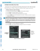
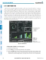
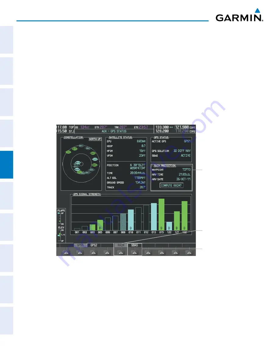
Figure 5-109 RAIM Prediction
SBAS
Softkey
(displays SBAS Selection)
RAIM PREDICTION Box
- Prediction Waypoint
- Arrival Time
- Arrival Date
- RAIM Status
RAIM
Softkey
(displays RAIM
PREDICTION)
Predicting RAIM availability at a selected waypoint:
1)
Select the AUX-GPS Status Page.
2)
Press the
FMS
Knob. The RAIM Prediction ‘WAYPOINT’ field is highlighted.
3)
Turn the small
FMS
Knob to display the Waypoint Information Window. (Turning it clockwise displays a blank
Waypoint Information Window, turning it counter-clockwise displays the Waypoint Information Window with a
waypoint selection submenu allowing selection of active flight plan, nearest, recent, user, or airway waypoints)


