4-108
Garmin G500H Pilot’s Guide
190-01150-02 Rev. J
For
ewor
d
Sec 1 System
Sec 2
PFD
Sec 3
MFD
Sec 4
Hazar
d
Avoidance
Sec 5
Additional Featur
es
Sec 6
Annun. & Alerts
Sec 7
Symbols
Sec 8
Glossary
Appendix A
Appendix B
Index
4.9.3
NEXRAD Intensity
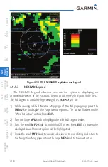
Colors are used to identify the different NEXRAD echo intensities (reflectivity)
measured in dBZ (decibels of Z). “Reflectivity” is the amount of transmitted power
returned to the radar receiver. Reflectivity (designated by the letter Z) covers a
wide range of signals (from very weak to very strong). So, a more convenient
number for calculations and comparison, a decibel (or logarithmic) scale (dBZ),
is used. The dBZ values increase as the strength of the signal returned to the
radar increases.
4.9.4
NEXRAD
When enabled, NEXRAD weather information is shown. Composite data
from all of the NEXRAD radar sites in the United States is shown. This data is
composed of the maximum reflectivity from the individual radar sweeps. The
display of the information is color-coded to indicate the weather level severity.
Refer to the legend for a description of the color code.
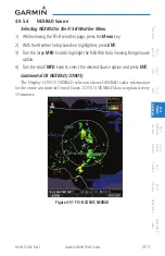
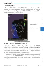
The NEXRAD option has selections of Regional, CONUS, or Combined
NEXRAD. CONUS NEXRAD includes a composite of available NEXRAD radar
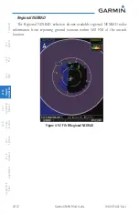
imagery across the 48 states. Regional NEXRAD is a composite of available
NEXRAD radar imagery in a local area, showing a more detailed image
than CONUS NEXRAD. FIS-B weather data reception requires line-of-site
communication between the receiver and the ADS-B ground station. Incomplete
Regional and/or CONUS NEXRAD imagery displayed on the MAP and FIS-B
Weather Pages of the affected products is an indicator of poor FIS-B reception.
Affected Areas
Any area in the continental United States (CONUS) or Alaska where the
distance from ADS-B ground stations, or the combined effect of distance and
low altitude, is sufficiently great may cause poor reception. A good source of
information for ground station coverage can be found at:
http://www.faa.gov/
Reception will improve in some affected areas as the FAA completes the
NextGen ADS-B ground station infrastructure. However, due to line-of-sight
broadcast characteristics, operators with properly installed and functioning
equipment may still receive incomplete FIS-B data when signal reception is
limited by the distance from ground stations combined with a low altitude.
Summary of Contents for G500H
Page 1: ...G500H Pilot s Guide ...
Page 365: ......


