


4-36
Garmin G500H Pilot’s Guide
190-01150-02 Rev. J
For
ewor
d
Sec 1 System
Sec 2
PFD
Sec 3
MFD
Sec 4
Hazar
d
Avoidance
Sec 5
Additional Featur
es
Sec 6
Annun. & Alerts
Sec 7
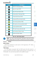
Symbols
Sec 8
Glossary
Appendix A
Appendix B
Index
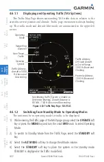
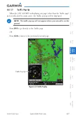
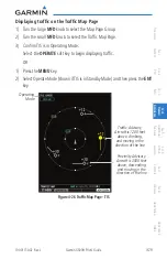
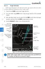
Switching Between TIS Operating Modes
1) Turn the large
MFD
knob to the MAP page group and then turn the small
MFD
knob to the Traffic Map Page.
2) Select the
STANDBY
or
OPERATE
soft key to switch between modes. The mode
is displayed in the upper left corner of the Traffic Map Page.
OR
1) Press the
MENU
key.
2) Select Operate mode or Standby mode whether airborne or on the ground.
3) Press the
ENT
key.
NOTE:
An alert will be generated when Standby is selected and the aircraft
is in the air.
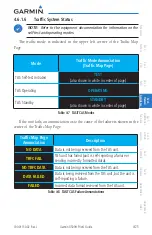
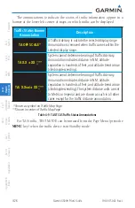
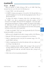
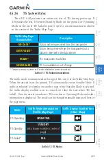
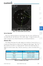
The annunciations indicate the status of traffic information appear in a banner
at the lower left corner of maps on which traffic can be displayed.
Traffic Status
Banner
Annunciation
Description
TA OFF SCALE*
A Traffic Advisory is outside the selected display range
Annunciation is removed when traffic comes within the selected
display range
TA/ X.X
NM
/± XX
↕
**
System cannot determine bearing of Traffic Advisory
Annunciation indicates distance in NM, altitude separation
in hundreds of feet, and altitude trend arrow (climbing/
descending)
AGE MM:SS
Appears if traffic data is not refreshed within 6 seconds
If after another 6 seconds data is not received, traffic is removed
from the display
The quality of displayed traffic information is reduced as the age
increases
TRFC COAST
The displayed data is not current (6 to 12 seconds since last
message)
The quality of displayed traffic information is reduced when this
message is displayed
Summary of Contents for G500H
Page 1: ...G500H Pilot s Guide ...
Page 365: ......