7-4
Pilot’s Guide
190-01717-10 Rev. H
Terrain Awareness
7.2
Database Limitations
NOTE
Garmin cross-validates terrain and obstacle data in accordance with
TSO-C151c. However, the information should never be considered
all-inclusive. Database inaccuracies or omissions may exist.
Terrain and obstacle data are not available when the aircraft is operating outside of
the installed database coverage area.
Garmin obtains terrain and obstacle data from government sources and cannot
independently verify the accuracy and completeness of the information. Pilots must
familiarize themselves with the appropriate charts and other data for safe flight.
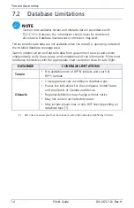
[1]
HOT lines are power lines that share location with other obstacles identified by the FAA.
DATABASE
COVERAGE LIMITATIONS
Terrain
•
Not available north of 89º N latitude and south of
89º S latitude
Obstacle
•
Coverage areas vary according to database type
•
Power line indications for the contiguous United States
and small parts of Canada and Mexico
•
Regional definitions may change without notice
•
May not contain uncharted obstacles
•
May include power lines or only HOT lines depending on
database type [1]
Summary of Contents for G500
Page 1: ...G500 H G600 G700 TXi Pilot s Guide ...
Page 12: ...x Pilot s Guide 190 01717 10 Rev H INTENTIONALLY LEFT BLANK ...
Page 110: ...1 82 Pilot s Guide 190 01717 10 Rev H INTENTIONALLY LEFT BLANK ...
Page 118: ...2 8 Pilot s Guide 190 01717 10 Rev H Primary Flight Display Reference Controls Menu Options ...
Page 244: ...4 48 Pilot s Guide 190 01717 10 Rev H INTENTIONALLY LEFT BLANK ...
Page 272: ...5 28 Pilot s Guide 190 01717 10 Rev H Weather Awareness 5 23 1 SiriusXM Weather Setup ...
Page 276: ...5 32 Pilot s Guide 190 01717 10 Rev H Weather Awareness 5 24 2 FIS B Weather Setup ...
Page 280: ...5 36 Pilot s Guide 190 01717 10 Rev H Weather Awareness 5 25 4 Connext Weather Setup ...
Page 354: ...7 34 Pilot s Guide 190 01717 10 Rev H INTENTIONALLY LEFT BLANK ...
Page 439: ......
Page 440: ...190 01717 10 Rev H ...

