


3-4
Pilot’s Guide
190-01717-10 Rev. H
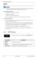
Advanced Features
3.1
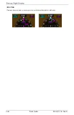
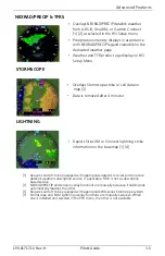
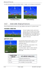
HSI Map Overlays
TOPO
TERRAIN
OBSTACLES AND WIRES
TRAFFIC
•
Topographic map depicting terrain elevation
using a color scale similar to Sectional Charts
•
Terrain map depicting terrain elevation relative
to aircraft altitude
•
Uses the same color scale as the dedicated
Terrain page
•
NEXRAD weather overlay is disabled to
prevent confusion of depicting radar and
terrain data with similar colors
•
Depicts obstacle and wire elevations relative to
aircraft altitude
•
Uses the same color scale as the dedicated
Terrain page
•
Data removed when viewing range is >5 nm
•
Displays traffic using a NORMAL altitude filter
•
Data removed when viewing range is >20 nm
Summary of Contents for G500
Page 1: ...G500 H G600 G700 TXi Pilot s Guide ...
Page 12: ...x Pilot s Guide 190 01717 10 Rev H INTENTIONALLY LEFT BLANK ...
Page 110: ...1 82 Pilot s Guide 190 01717 10 Rev H INTENTIONALLY LEFT BLANK ...
Page 118: ...2 8 Pilot s Guide 190 01717 10 Rev H Primary Flight Display Reference Controls Menu Options ...
Page 244: ...4 48 Pilot s Guide 190 01717 10 Rev H INTENTIONALLY LEFT BLANK ...
Page 272: ...5 28 Pilot s Guide 190 01717 10 Rev H Weather Awareness 5 23 1 SiriusXM Weather Setup ...
Page 276: ...5 32 Pilot s Guide 190 01717 10 Rev H Weather Awareness 5 24 2 FIS B Weather Setup ...
Page 280: ...5 36 Pilot s Guide 190 01717 10 Rev H Weather Awareness 5 25 4 Connext Weather Setup ...
Page 354: ...7 34 Pilot s Guide 190 01717 10 Rev H INTENTIONALLY LEFT BLANK ...
Page 439: ......
Page 440: ...190 01717 10 Rev H ...