


5-12
Pilot’s Guide
190-01717-10 Rev. H
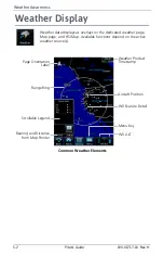
Weather Awareness
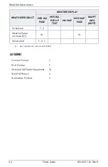
5.5
Echo Tops
5.6
Clouds
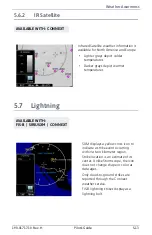
5.6.1
Cloud Tops
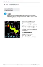
AVAILABLE WITH: SIRIUSXM
AVAILABLE WITH:
FIS-B | SIRIUSXM
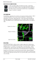
Depicts the location, elevation, and
direction of NEXRAD radar echoes.
This information is useful for gauging
storm intensity in a relative sense. A
higher radar echo means a stronger
storm updraft.
Due to similarities in color schemes,
this product is mutually exclusive with
Cloud Tops.
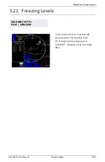
Indicates the altitude of the highest
visible portions of a cloud at the time
of measurement.
SXM cloud top altitude data is
estimated from IR satellite imagery.
FIS-B cloud top data is generated by a
computer model and has limited
accuracy compared to actual
conditions.
Due to similarities in color schemes,
this product is mutually exclusive with
Echo Tops.
Summary of Contents for G500
Page 1: ...G500 H G600 G700 TXi Pilot s Guide ...
Page 12: ...x Pilot s Guide 190 01717 10 Rev H INTENTIONALLY LEFT BLANK ...
Page 110: ...1 82 Pilot s Guide 190 01717 10 Rev H INTENTIONALLY LEFT BLANK ...
Page 118: ...2 8 Pilot s Guide 190 01717 10 Rev H Primary Flight Display Reference Controls Menu Options ...
Page 244: ...4 48 Pilot s Guide 190 01717 10 Rev H INTENTIONALLY LEFT BLANK ...
Page 272: ...5 28 Pilot s Guide 190 01717 10 Rev H Weather Awareness 5 23 1 SiriusXM Weather Setup ...
Page 276: ...5 32 Pilot s Guide 190 01717 10 Rev H Weather Awareness 5 24 2 FIS B Weather Setup ...
Page 280: ...5 36 Pilot s Guide 190 01717 10 Rev H Weather Awareness 5 25 4 Connext Weather Setup ...
Page 354: ...7 34 Pilot s Guide 190 01717 10 Rev H INTENTIONALLY LEFT BLANK ...
Page 439: ......
Page 440: ...190 01717 10 Rev H ...