4-22
Pilot’s Guide
190-01717-10 Rev. H
Multi-Function Display
4.6.3
Smart Airspace
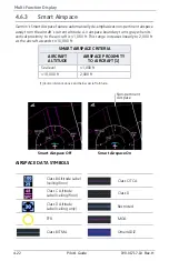
Garmin’s Smart Airspace feature automatically de-emphasizes non-pertinent airspace
away from the aircraft’s current altitude. An airspace boundary turns gray when its
vertical proximity to the aircraft is >1,000 ft. This range increases linearly to 2,000 ft
as the aircraft ascends to 10,000 ft.
[1]Vertical distance above and below aircraft altitude.
AIRSPACE DATA SYMBOLS
SMART AIRSPACE CRITERIA
AIRCRAFT
ALTITUDE
AIRSPACE PROXIMITY
TO AIRCRAFT [1]
Sea level
>1,000 ft
>10,000 ft
2,000 ft
Class B Altitude Label
(ceiling/floor)
Class C/TCA
Class C Altitude
Label (ceiling/floor)
Class D
Class D Altitude
Label (ceiling only)
Restricted
TFR
MOA
Class B/TMA
Other/ADIZ
Smart Airspace Off
Smart Airspace On
Non-pertinent
Airspace
Summary of Contents for G500
Page 1: ...G500 H G600 G700 TXi Pilot s Guide ...
Page 12: ...x Pilot s Guide 190 01717 10 Rev H INTENTIONALLY LEFT BLANK ...
Page 110: ...1 82 Pilot s Guide 190 01717 10 Rev H INTENTIONALLY LEFT BLANK ...
Page 118: ...2 8 Pilot s Guide 190 01717 10 Rev H Primary Flight Display Reference Controls Menu Options ...
Page 244: ...4 48 Pilot s Guide 190 01717 10 Rev H INTENTIONALLY LEFT BLANK ...
Page 272: ...5 28 Pilot s Guide 190 01717 10 Rev H Weather Awareness 5 23 1 SiriusXM Weather Setup ...
Page 276: ...5 32 Pilot s Guide 190 01717 10 Rev H Weather Awareness 5 24 2 FIS B Weather Setup ...
Page 280: ...5 36 Pilot s Guide 190 01717 10 Rev H Weather Awareness 5 25 4 Connext Weather Setup ...
Page 354: ...7 34 Pilot s Guide 190 01717 10 Rev H INTENTIONALLY LEFT BLANK ...
Page 439: ......
Page 440: ...190 01717 10 Rev H ...

