


Garmin G1000 NXi Cockpit Reference Guide for the da62
190-02622-00 Rev. A
101
Hazard avoidance
Flight
Instruments
EIS
Nav/Com/
XPDR/Audio
Flight
Management
Hazar
d
Avoidance
AFCS
Additional
Featur
es
Annun/Alerts
Appendix
Index
Flight
Instruments
EIS
Nav/Com/
XP
d
R/
a
udio
Flight
Management
Hazar
d
avoidance
a
FCS
a
dditional
Featur
es
a
bnormal
o
per
ation
a
nnun/
a
lerts
a
ppendix
Index
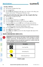
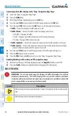
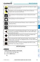
• Below:
Displays Other Non-Threat and Proximity Advisory traffic from 2700 feet
above the aircraft to 9900 feet below the aircraft. Typically used during descent
phase of flight.
• UNREST
(unrestricted)
:
All traffic is displayed from 9900 feet above and 9900 feet
below the aircraft.
3)
To return to the Traffic Page, select the
Back
Softkey.
or:
1)
Press the
MENU
Key.
2)
Turn the small
FMS
Knob to select one of the following (see softkey description in the
previous step 2):
• above
.
• Normal
.
• Below
.
• Unrestricted
.
3)
Select the
ENT
Softkey.
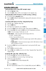
t
RAFFiC
m
Ap
p
Age
d
isplAy
R
Ange
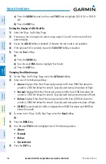
The display range on the 'Map - Traffic Map' Page can be changed at any time. Map range is
adjustable with the
Joystick
, and rings on the map denote the ranges.
Changing the display range on the ‘Map - Traffic Map’ Page:
1)
Select the ‘Map -Traffic Map’ Page.
2)
Turn the
Joystick
.
3)
The following range options are available:
•
750 ft (with optional ADS-B).
•
750 ft and 1500 ft (with optional ADS-B).
•
1500 ft and 0.5 nm (with optional ADS-B).
•
0.5 nm and 1 nm (with optional ADS-B).
•
1 nm and 2 nm (with optional ADS-B).
•
2 nm and 6 nm.
•
6 nm and 12 nm.
•
12 nm and 24 nm.
•
24 nm and 40 nm.
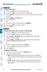
Enabling/disabling traffic information (MFd maps other than the 'Map - Traffic Map'
Page):
1)
Select the
Map opt
Softkey.
2)
Select the
Traffic
Softkey. Traffic is now displayed on the map.
Summary of Contents for G1000 NXi
Page 1: ...Cockpit Reference Guide Diamond DA62 System Software Version 2056 10 or later...
Page 2: ......
Page 4: ......
Page 219: ......


