Astro
®
owner’s manual
GPS-enabled dog tracking system
Page 1: ...Astro owner s manual GPS enabled dog tracking system...
Page 2: ...o is strictly prohibited Information in this document is subject to change without notice Garmin reserves the right to change or improve its products and to make changes in the content without obligat...
Page 3: ...Adding Dogs 9 Collar Lock 10 Astro and DC 40 Tips 11 Locations 13 Marking a Location 13 Navigating to a Marked Location 14 Editing a Marked Location 14 Averaging Your Location 15 Projecting a Locatio...
Page 4: ...g the Device Tones 40 Customizing the Main Menu 40 Customizing the Map Setup 40 Routing Settings 42 Geocache Settings 43 Marine Alarms 43 Time Settings 44 Units Settings 44 Heading Settings 45 Altimet...
Page 5: ...ompleting our online registration today Go to http my garmin com Keep the original sales receipt or a photocopy in a safe place Contacting Garmin Product Support You can contact Garmin Product Support...
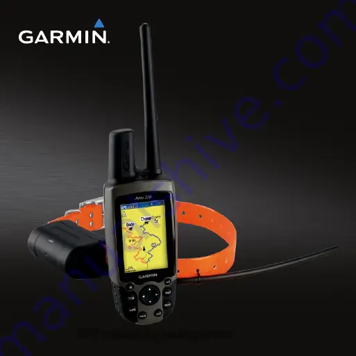
Page 6: ...g a high powered radio greater than 5 watts in close proximity to the Astro It may cause irreversible damage to the Astro GPS antenna VHF antenna Power key Display Keypad Belt clip button Wrist strap...
Page 7: ...na Power key Keypad DOG Press to view the Dog Tracker page MARK Press to mark your current location BACK Press to cancel data entry or return to the previous menu or page MAP Press to view the map MEN...
Page 8: ...Press ENTER to select a brightness level and close the menu Manual Conventions Press Use the keys on the device Select Use the Rocker to select an option or an item in a list and press ENTER Field The...
Page 9: ...40 on the channel it is receiving Indicates the remaining battery power On Screen Messages When an on screen message appears you can press ENTER to acknowledge the message and close the window Messag...
Page 10: ...as linked with the Astro at the factory If you are using a DC 40 that you purchased separately follow the instructions for adding a new dog on page 9 to establish communications with the Astro Navigat...
Page 11: ...olding the Astro level and the dog is farther than 30 feet 9 1 meters away At less than that distance NEAR appears instead of a distance and the dog pointer is shortened Note When you are close to the...
Page 12: ...board appears 3 Enter the name of the dog Changing the Dog Type You can identify the dog type so that the appropriate dog status symbols appear 1 Press DOG ENTER 2 Press MENU 3 Select Change Dog Unit...
Page 13: ...u are facing To stabilize the objects set the orientation to North Up page 40 Adding Dogs The Astro can track up to ten dogs with DC 40 collars If you purchase additional DC 40 devices you can link th...
Page 14: ...n but they create a less detailed dog track and collected statistics 7 Bring the Astro within a few feet of the DC 40 8 Follow the on screen instructions Removing Dogs 1 On the Dog Tracker page press...
Page 15: ...on page 12 The Astro can track up to ten dogs with DC 40 collars Only three dogs can be viewed at one time on the Dog Tracker page To reduce the text size press MENU and select Small Numbers Go to www...
Page 16: ...ath of radio signals degrade the quality of the signals Keeping an unobstructed line of sight between your Astro and your dog s DC 40 produces the best communication signal Obstructed radio waves resu...
Page 17: ...se a default location name such as Truck or Camp 3 Select OK Marking a Covey You can mark a covey location and enter the estimated number of birds flushed and the number of birds taken 1 Press MARK 2...
Page 18: ...cation on the Map 1 From the main menu select Advanced Find Marked Locations 2 Select a marked location 3 Select Map to show the marked location on the map 4 Press ENTER to place a MOVE marker next to...
Page 19: ...ings at the same location and uses the average value to provide more accuracy 1 Press MARK 2 Select New Avg to begin averaging 3 When the Estimated Accuracy field reaches the level of accuracy you wan...
Page 20: ...ocation Scaling the Map Press IN and OUT to change the map scale When you zoom in the accuracy of your location is indicated by an accuracy circle The smaller the circle the more precise your location...
Page 21: ...elect Change Data Fields 6 Select a field A list of data field options appears page 46 7 Select an option Measuring Distance You can measure the distance between two points 1 Press MAP MENU 2 Select M...
Page 22: ...rom the main menu select Advanced Find Marked Locations 2 Select a marked location 3 Select Go To Finding a Location by Name 1 From the main menu select Advanced Find 2 Select the type of item you wan...
Page 23: ...he 1 From the main menu select Advanced Find Geocache 2 Select a geocache 3 Select Go To to navigate to the geocache location When a geocache is found the Astro marks the cache as found logs an entry...
Page 24: ...rmin com Finding an Address 1 From the main menu select Advanced Find Addresses If your device has acquired satellite signals the ENTER Region field is populated with your current region 2 Enter the c...
Page 25: ...puter displays your current speed average speed maximum speed trip odometer and other helpful statistics Resetting the Trip Computer 1 From the main menu select Advanced GPS Applications Trip Computer...
Page 26: ...regardless of the direction you are moving When the bearing pointer points toward the top of the compass you are traveling directly toward your destination Navigating With the Course Pointer This is...
Page 27: ...ed on your original starting point 4 Move back to the course line to destination to compensate for deviation and to get back on course Navigating with Sight N Go You can point the device at an object...
Page 28: ...luence magnetic fields such as cars buildings or overhead power lines You should calibrate the compass after moving long distances experiencing temperature changes or changing the batteries 1 Press DO...
Page 29: ...lot to view the elevation or pressure reading the time of day and the date when the point was recorded Navigating to a Point on the Plot 1 From the main menu select Advanced GPS Applications Altimeter...
Page 30: ...nu select Advanced GPS Applications Altimeter 3 Press MENU 4 Select Calibrate Altimeter 5 Follow the on screen instructions Tracks A track is a recording of your path and of the path of your dog The t...
Page 31: ...e view the calculated area and change the units for the calculated area You can also change the color for the track on the map Changing the color of a dog s saved track also changes the dog pointer co...
Page 32: ...ll across the track profile While scrolling press ENTER to show the point on the map 6 Press up or down on the Rocker to set the zoom range Digital Elevation Models Maps Using Digital Elevation Models...
Page 33: ...Move the map pointer to a location on the track 5 Press MARK 6 Select New 7 If necessary edit the location information 8 Select OK Calculating the Area of a Track 1 From the main menu select Advanced...
Page 34: ...re points to the route Navigating a Saved Route 1 From the main menu select Advanced GPS Applications Routes 2 Select a route 3 Select Navigate Stopping Navigation Press MENU Stop Navigation Editing a...
Page 35: ...main menu select Advanced GPS Applications Routes 2 Press MENU 3 Select Off Road Transition 4 Select the method to use when advancing to the next point in your route Select Auto to advance to the nex...
Page 36: ...e map Proximity Alarms You can define an alarm radius around a marked location A tone sounds when you enter the designated radius Adding a Proximity Location 1 From the main menu select Advanced GPS A...
Page 37: ...w Navigating with Turn Preview You must be navigating a route on roads to display the turn preview information 1 From the main menu select Advanced GPS Applications Turn Preview 2 Scroll through all o...
Page 38: ...MENU 3 Select an option Select Use With GPS Off to turn the GPS on and off Select Track Up to display the page with North toward the top of the screen or with your current track toward the top of the...
Page 39: ...essories Calendar 2 Select a day 3 Press MENU 4 Select Add Point 5 Select a category 6 Select a location 7 Select Use to place the location on the day page Calculator The Astro has a standard calculat...
Page 40: ...Distance to automatically mark the lap at a specific distance Press MENU and select Set Lap Distance to enter a value Viewing Sunrise and Sunset Information You can view the time of sunrise sunset moo...
Page 41: ...om the main menu select Advanced Accessories View Hunting Almanac 2 Select an option Select Date to change the date Select Location to change the location Games From the main menu select Advanced Acce...
Page 42: ...ou to select the type of battery you are using Text Language sets the text language on the device External Power Lost sets the device to stay on or turn off when external power is removed Proximity Al...
Page 43: ...ned its own movements to a small area for 60 seconds GPS Lost Alert indicates that the dog s DC 40 has lost GPS satellite signals Lost Communication Alert indicates that the Astro is not receiving sig...
Page 44: ...ttings Main Menu 2 Select a menu item 3 Select an option Select Move and change the order of the list Select Insert to add a new item to the list Select Remove to delete an item from the list Customiz...
Page 45: ...he maximum zoom at which saved tracks are shown Track Log sets the maximum zoom at which active track logs are shown Track Points sets the maximum number of track points used to record a track Go To L...
Page 46: ...uto the location appears when the map pointer passes over it Symbol Set allows you to select the map symbol set Auto GARMIN NOAA or International Routing Settings From the main menu select Advanced Se...
Page 47: ...y the device calculates a route Calculate Routes for allows you to select your vehicle type or transportation type in order to calculate the most practical route Avoid allows you to select road types...
Page 48: ...selected time zone Units Settings From the main menu select Advanced Settings Units Note Do not change the position format or the map datum coordinate system unless you are using a map or chart that s...
Page 49: ...a specific user value Switch to compass heading when below sets the speed to switch to a compass heading when you exceed the specified time for more than sets the time to switch to a compass heading...
Page 50: ...cent Ascent Maximum The maximum ascent rate in feet meters per minute Data Field Description Ascent Total The total elevation distance ascended Barometer The calibrated current pressure Bearing The di...
Page 51: ...destination elevation Heading The direction you are moving Location lat lon Displays the current position in the default position format regardless of the selected settings Data Field Description Loca...
Page 52: ...eeded to reach your final destination Time to Next The estimated time needed until you reach the next point on the route Data Field Description To Course The direction in which you must move to return...
Page 53: ...ription Vertical Speed Your rate of altitude gain or loss over time Vert Speed to Dest The measurement of your rate of ascent or descent to a predetermined altitude Waypoint at Dest The last point on...
Page 54: ...lock optional maps Download geocaches to your device Buying Accessories Go to http buy garmin com or contact your Garmin dealer for information about optional accessories preloaded map data cards acce...
Page 55: ...your own Phillips screwdriver to replace the DC 40 collar 1 Carefully cut the zip tie that secures the VHF antenna to the collar 2 Remove the two screws on the back plate of the DC 40 3 Lift off the...
Page 56: ...ar Trim the zip tie and any sharp edges Changing the Fuse in the Vehicle Power Cable NOTICE When replacing the fuse do not lose any of the small pieces and make sure they are put back in the proper po...
Page 57: ...a Memory Card You can purchase microSD memory cards from an electronics supplier or purchase preloaded map data cards from your Garmin dealer In addition to map and data storage the memory cards can b...
Page 58: ...your computer 2 Pull up the weather cap from the mini USB port 3 Plug the small end of the USB cable into the mini USB port 4 From the main menu select Advanced Settings System 5 Press MENU 6 Select M...
Page 59: ...The DC 40 stores more detailed tracks of the dog s movements You can use the Astro to transfer these tracks to the BaseCamp software www garmin com on your computer 1 Open BaseCamp 2 Connect the Astr...
Page 60: ...from your computer Updating the Astro Software Before you can update the software you must connect the Astro to your computer page 54 note Updating the software does not erase any of your data or sett...
Page 61: ...rgent solution 2 Wipe it dry Cleaning the Screen 1 Use a soft clean lint free cloth 2 If necessary use water isopropyl alcohol or eyeglass lens cleaner 3 Apply the liquid to the cloth and gently wipe...
Page 62: ...information on page 59 DC 40 Water resistance Water resistant to IEC 60529 IPX7 Battery type Internal rechargeable lithium ion battery Battery life From 17 to 48 hours Recharging takes approximately 4...
Page 63: ...turning the D ring 1 4 turn counterclockwise and pulling up 2 Insert the batteries observing polarity 3 Replace the battery cover Selecting the Battery Type 1 From the main menu select Advanced Setti...
Page 64: ...ery Life Using the Astro Battery Save Option From the main menu select Advanced Settings System GPS Battery Saver Decreasing the Backlight Extensive use of screen backlighting can significantly reduce...
Page 65: ...e Astro within a few feet of the DC 40 7 Follow the on screen instructions Charging the DC 40 Charging a depleted DC 40 battery takes 4 hours 1 Connect the power cable to an appropriate electrical sou...
Page 66: ...the device from the vehicle or store it out of direct sunlight such as in the glove box Do not use a sharp object to remove the batteries Do not puncture or incinerate the device or battery Keep the...
Page 67: ...ox Do not incinerate the DC 40 or the battery When storing the device for a limited length of time store within the following temperature range from 4 F to 104 F from 20 to 40 C When storing the devic...
Page 68: ...with vehicle operating controls such as the steering wheel the foot pedals or the transmission levers Do not place the device in front of or above any airbag See diagram Do not place an unsecured dev...
Page 69: ...to posted road signs and road conditions The device is designed to provide route suggestions It is not a replacement for driver attentiveness and good judgement Do not follow route suggestions if the...
Page 70: ...s and industry reviewed the available body of research to develop the ANSI Standard C95 1 The design of your radio complies with the FCC guidelines and those standards For body worn and face held oper...
Page 71: ...rference and should turn the radio off immediately if you have any reason to suspect that interference is taking place Hearing Aids Some digital wireless radios may interfere with some hearing aids In...
Page 72: ...n off two way radio Obey all signs and instructions Potentially Explosive Atmospheres Turn your radio OFF and do not remove your battery when you are in any area with a potentially explosive atmospher...
Page 73: ...n does not assume any responsibility for any fines penalties or damages that may be incurred as a result of any state or local law or ordinance relating to use of the product Windshield Mount Informat...
Page 74: ...igital device pursuant to part 15 of the FCC rules These limits are designed to provide reasonable protection against harmful interference in a residential installation This equipment generates uses a...
Page 75: ...gory I radiocommunication devices comply with Industry Canada Standard RSS 210 Category II radiocommunication devices comply with Industry Canada Standard RSS 310 Map Data Information Garmin uses a co...
Page 76: ...and or its third party providers and is protected under the United States of America copyright laws and international copyright treaties You further acknowledge that the structure organization and cod...
Page 77: ...age caused by accident abuse misuse water flood fire or other acts of nature or external causes iv damage caused by service performed by anyone who is not an authorized service provider of Garmin or v...
Page 78: ...NS MAY NOT APPLY TO YOU Garmin retains the exclusive right to repair or replace with a new or newly overhauled replacement product the device or software or offer a full refund of the purchase price a...
Page 79: ...ough an online auction International Purchases A separate warranty may be provided by international distributors for devices purchased outside the United States depending on the country If applicable...
Page 80: ...ns 58 storage 59 type 59 warnings 62 64 battery save option 60 bearing pointer 22 belt clip 51 C calculator 35 calendar 35 calibrating altimeter 26 45 compass 24 caring for the devices 57 charging the...
Page 81: ...9 settings 43 GPS applications 21 elevation 34 settings 34 38 signals 46 H heading settings 45 highway page 32 hunting almanac 37 K keypad 3 L language 38 line of sight radio communication 12 lithium...
Page 82: ...ort 1 proximity alarms 32 R radio signals 12 58 65 recent finds 20 registering your device 1 routes 29 editing 30 follow road 42 off road 42 settings 42 S satellite page 34 satellite signals 5 6 11 34...
Page 83: ...its settings 44 updating software Astro 220 56 DC 30 56 V VHF antenna replacing 52 W WAAS 38 warnings and important information 62 75 warranty 73 WebUpdater 56 57 windshield mounting 69 wrist strap 50...
Page 84: ...n com 0470 2010 Garmin Ltd or its subsidiaries Garmin International Inc 1200 East 151st Street Olathe Kansas 66062 USA Garmin Europe Ltd Liberty House Hounsdown Business Park Southampton Hampshire SO4...