background image

Reference

30

Creating Routes

Find

 — Choose this option if you want to find a known place such as a restaurant, hotel, waypoint, or 

an address. Use the Find option in the same way that it is discussed in the last section, Finding Places by 
Using the FIND Menu.

Route Preference Window

Once you mark your start and end points for a route, you can decide how you want the route to be 
calculated: by using the fastest time, by taking the shortest distance, or by travelling off route.

Faster Time

 — Choose this option if you want your StreetPilot to use time as the criteria for calculating 

your route. This means that the driving time will be shorter but the distance might be longer.

Shorter Distance

 — Choose this option if you want your StreetPilot to use distance as the criteria for 

calculating your route. This means that the distance might be shorter but you may have to drive longer.

Off Road

 — Choose this option to view a direct-line route to your destination. This option does not 

provide a turn-by-turn route. It merely displays a straight line from your end point to your start point; the 
voice guidance tells you the direction and distance to your destination. Use this option if you are travelling 
where obscure roads (or no roads) might be.
As soon as your route is created, your StreetPilot begins to navigate the route. If at any time 
you wish to STOP a route, select 

Stop Route

 from the 

Route

 menu. To RESUME the route, 

select 

Resume Route

.

Setting a HOME Waypoint

Your StreetPilot includes a special feature that allows you to set a HOME waypoint that can be your home, 
office, or any other place to which you return most often. Once set, you can opt to go “HOME.” For 
example, if you are driving in a new city or down an unknown  street and you want to easily find your way 
home, simply press your StreetPilot’s 

FIND

 key two times. A window asking you to verify that you want to 

route home will appear. Select 

Yes

, and your StreetPilot will then direct you to your HOME location. 

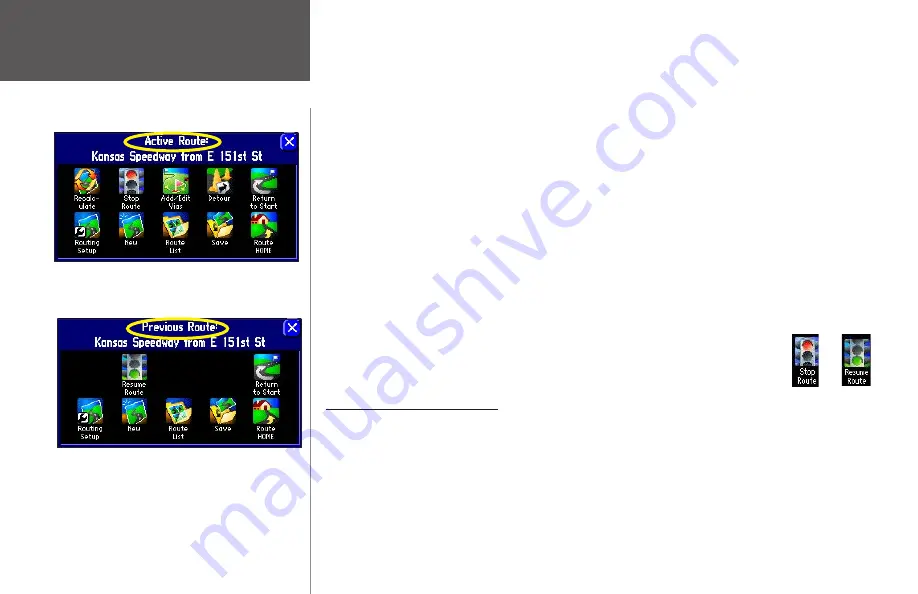
The appearance of the Route menu depends on if you 
are currently navigating a route (top) or if you have 
recently completed a route (bottom).

Summary of Contents for 2610/2650

Page 1: ...StreetPilot 2610 2650 portable car navigation owner s manual StreetPilot 2610 pictured StreetPilot 2650 not shown...

Page 2: ...ed and to print one copy of this manual or of any revision hereto provided that such electronic or printed copy of this manual must contain the complete text of this copyright notice and provided furt...

Page 3: ...asics read the sections on customizing your StreetPilot to suit your navigational and personal needs Lastly learn the basics of GPS navigation as well as how to understand the features on the StreetPi...

Page 4: ...ction Mount External Speaker with 12 24 volt Adapter Cable vehicle adapter A C Power Adapter PC USB Interface Cable DR Dead Reckoning Installation Cable 2650 Only Alphanumeric Remote Control Requires...

Page 5: ...ng a Waypoint 24 Advanced Find Features 25 Planning a Trip 26 Finding Recently Found Places 27 CREATING YOUR OWN ROUTES 28 Creating your First Route 29 Setting a HOME Waypoint 30 Saving a Route 31 Del...

Page 6: ...a gold sheet that states IMPORTANT UNLOCK CODE ENCLOSED at the top and includes an actual unlock code at the bottom USB Cable Do NOT connect this cable to your computer until after you have downloaded...

Page 7: ...t In addition to your StreetPilot you will need the following items that are included in the StreetPilot package Vehicle adapter This is a 12 24 volt DC adapter with an external speaker system that co...

Page 8: ...to your vehicle s cigarette lighter Turn on the StreetPilot so that it can nd satellites When your StreetPilot has established a satellite x your screen should display a Ready to Navigate message as...

Page 9: ...con located on the Find menu from Step 2 The list of restaurants in your area will appear on a page similar to the one shown below Step 5 To create a route to this restaurant touch the Go To button lo...

Page 10: ...to re reg ister using our online system Many services provided by our new product registration system are now being automated and re registering your purchase ensures you the best possible support fro...

Page 11: ...se and tilt forward backward External Antenna Connector Connection for optional external antenna Back View USB Connector Connects unit with a PC to add maps to the CF card or to upload software upgrad...

Page 12: ...n or damage may result The touchscreen should be cleaned using a soft clean lint free cloth Water isopropyl alcohol or eyeglass cleaner can be used if needed If these are used apply the liquid to the...

Page 13: ...two seconds a Routes page will appear PAGE MARK Key PAGE switches between a variety a pages that you can view on your StreetPilot It also returns you to a main page if you have previously selected an...

Page 14: ...perform functions similar to the unit s keypad controls You will notice only subtle differences between the two As on the keypad the remote control features PAGE MENU FIND and SPEAK keys Thus you can...

Page 15: ...1 key only accepts one press and SPACE 0 only accepts two key presses In order for the remote to operate properly be sure to point the IR infrared window on the remote towards the unobstructed IR win...

Page 16: ...ures on the Map page Practice using these features before navigating an actual route so that you can quickly understand what you are seeing on the Map page and thus limit time looking away from the ro...

Page 17: ...age and a magnifying glass that lets you zoom out of an area The panning hand allows you to move around the Map page by touching the screen touchscreen with your nger this action is called panning Pan...

Page 18: ...on your Map page North Up shows your Map page with North always at the top as if you were reading a paper map Thus as you are driving the vehicle icon on your Map page will move to the left if you ar...

Page 19: ...features speci c details such as addresses businesses parks and other points of interest Thus if you are viewing Denver at a map scale of 800 feet your StreetPilot will display information from its ba...

Page 20: ...rawn with the pointer at the center When the pointer is placed on a map object the name of that object is highlighted and an i Information icon appears in the upper right corner In the example above t...

Page 21: ...g else touch the current name 011 and a mini keyboard page will appear allowing you to type in a new name You can also touch the icon to the left of the name to change the icon The mini keyboard shown...

Page 22: ...oute line It tells you what direction to go as well as the direction in which you are traveling Customizable data tabs are pre set to display information such as your speed the distance you have trave...

Page 23: ...tion always appears on the Map page Another StreetPilot feature allows you to look ahead on the Map page so that you can view areas beyond your current position but without interrupting the function o...

Page 24: ...ds If you need to see it again simply press SPEAK and it will reappear Shows how many miles until you reach the upcoming turn Shows the approximate time left until you reach the upcoming turn Route Li...

Page 25: ...ess PAGE from your StreetPilot or from the remote control and the Current Route page appears The Current Route page keeps a log of your entire route Thus you can look beyond the next turn and even get...

Page 26: ...f the page Compass Ribbon Shows your current compass heading while moving with a red indicator arrow Speed This is the current vehicle speed displayed in miles or kilometers per hour Odometer A runnin...

Page 27: ...formation page A box containing various log names Job 1 Job 2 Job 3 OTHER None will appear 2 Select the desired Mileage Log name All mileage will be recorded in this log To rename a Mileage Log 1 Make...

Page 28: ...ly installed by an authorized Garmin installer Thus when you lose GPS reception your StreetPilot can acknowledge your turns as well as your distance travelled while you are driving In this way it can...

Page 29: ...s when you select By Name Note that when you use By Name all city names that are loaded in your mapping software will be searched For example if you are searching for Greensboro N C your search using...

Page 30: ...nter As Text icon Then enter your coordinates Near Map Pointer Use Near Map Pointer to nd cities that are near the area to which you have placed the map pointer while panning Near Destination Use Near...

Page 31: ...es of streets such as Avenue or Parkway For example if you are looking for E 205 Elm Ave enter 205 in the Number eld and Elm in the Street eld Then press Find A list of possible matches will appear on...

Page 32: ...from Kansas City to St Louis and within a 1 2 mile corridor width of any point on your route will appear under the Near Current Route tab The list displays places that are located ahead of or a short...

Page 33: ...me of the restaurant or other place you seek no matter which search method you used touch the name of the restaurant and its address and telephone number will appear Touch the green ag in the lower le...

Page 34: ...red in the StreetPilot can be found by touching the Waypoints icon from the Find menu See page 11 for more information on creating waypoints Here are the possible tab options that might appear Near He...

Page 35: ...you can also perform a straight line measurement of that place to see the distance from it to your current position or any other location To view this measuring tool press the unit s MENU key and then...

Page 36: ...ok for a place to stay in Fraser Your StreetPilot will return the names of places to lodge Touch the name of your desired lodging place to view the information page about it and so that the lodge will...

Page 37: ...you cannot nd your sought after place quickly touch the All tab and narrow your search by selecting Points of Interest Addresses Intersections or Other If necessary scroll down the new list to nd you...

Page 38: ...ou have not yet created a route When you create a route and activate it the following options appear Recalculate Recalculates the active route for faster time or shorter distance This option is availa...

Page 39: ...corner of the Map page as the unit calculates the route as shown on the diagram at right A voice prompt sounds and a magenta route line appears The unit is now ready to navigate the new route Current...

Page 40: ...n This option does not provide a turn by turn route It merely displays a straight line from your end point to your start point the voice guidance tells you the direction and distance to your destinati...

Page 41: ...s house at which you are vacationing Then as you explore the surrounding area you can use the Route HOME feature to return you to your lodging place To change your HOME waypoint you must rst delete t...

Page 42: ...treetPilot You can also rename a saved route To do this select Route List from the Route Menu A Route List page will appear To delete or rename a single route highlight the intended route from the Rou...

Page 43: ...2 1 2 5 or 15 miles If you are in New York City for example and you see that the next few blocks are unusually congested with traf c you might want to opt for a 1 2 mile detour Once you select a dist...

Page 44: ...te that your current destination appears on this page 2 Select Add Via Point An Add Via Point page appears with two options for nding your location Use Map or Find 3 Select an option from the Add Via...

Page 45: ...imized for distance simply select Auto Arrange from the Edit Vias page as shown at right A window appears that asks if you also want your destination point to be reordered Answer Yes and the unit arra...

Page 46: ...een two points make sure you are currently viewing the Map page Then press the unit or remote MENU key A Menu page will appear Select Measure Distance from this page An on screen pointer a blue thumb...

Page 47: ...ecomes the current point You can measure distances from the Bistro to other locations To stop measuring points press the MENU key and then select the Stop Measuring icon Or simply touch the white arro...

Page 48: ...mbinations To have the unit automatically adjust the brightness place a check in the Automatic Brightness box For optimum Automatic Brightness results set the brightness to a middle level If Automatic...

Page 49: ...l Adjusts the amount of detail that will be displayed on your Map page Most shows maximum detail and Least shows minimum detail The higher the detail level the slower the map redrawing time Select Mos...

Page 50: ...the Map page select Off in the Text Size eld Max Zoom Speci es the maximum map scale at which a map item displays If AUTO is selected the maximum map scale is determined by the Detail setting to preve...

Page 51: ...omize the tabs recall that your StreetPilot uses two different sets of display tabs depending on your navigation mode When you are simply driving down the road with your StreetPilot turned on but you...

Page 52: ...bs 1 From the Tab Setup page select either the Mapping or Routing tab 2 Press MENU on the unit or remote A Menu page will appear 3 From the Menu page select Custom Setup 3 Select the tab button you wi...

Page 53: ...estination Distance To Turn Distance remaining to reach the next turn Time to Turn Estimated time to go before reaching the next turn To show hide all data tabs From the Map page press MENU on the uni...

Page 54: ...iginal Settings At some point you may desire to restore the default settings for one or more tabs on the System Setup Options menu You can restore the original settings by following the instructions b...

Page 55: ...ch tab item General tab Color Scheme Allows you to change the colors of the background and letters Dark Displays a black background with white letters Bright Displays a white background with black let...

Page 56: ...ou to turn the keypress beeper sounds On or Off A beep con rms that a key such as MENU FIND SPEAK on the unit or remote has been pressed Guidance tab Off Route Recalculation Controls how the StreetPil...

Page 57: ...ful when you are travelling outside of detailed map coverage areas or where no roads exist Custom Route calculations are based on the settings you create on the Custom Road Preferences page Select the...

Page 58: ...Likewise the StreetPilot may give you access to roads or turns that wouldn t be available to normal traf c Avoidance button The Avoidance button appears on the Routing tab and allows you to avoid cer...

Page 59: ...orner of the page A map of the avoided roads appears along with a default name usually street names You can change this name by touching it and entering a new name by using the mini keyboard that appe...

Page 60: ...f the page A map of the avoided area appears along with a default name usually AREA 000 You can change this name by touching it and entering a new name by using the mini keyboard that appears Move the...

Page 61: ...Auto Set button For example if you tend to drive slower than expected on minor roads then the Auto Set option should move the Minor Road Category preference bar towards Avoid to cause the unit to avo...

Page 62: ...East of the Prime Meridian the offset is positive In other words it is earlier in the day when you move West and later in the day when you move East Daylight Savings Can be turned On Off or set to Aut...

Page 63: ...language setup feature allows you to change the languages used for on screen text and for voice prompting Text Language This changes all on screen text on all pages and menus to the selected language...

Page 64: ...Format If you are using the Garmin USB cable to transfer data keep USB Format set to Garmin Change it to None only if you plan to use a serial cable instead of USB Serial Format If you are using the...

Page 65: ...a Menu page will appear From the Menu page select the Info icon and an Info page will appear Select the System Info icon and the System Info page will appear Software updates for your StreetPilot can...

Page 66: ...culate a 2D position latitude and longitude and track movement With four or more satellites in view the receiver can determine your 3D position latitude longitude and altitude Once your position has b...

Page 67: ...n updates your position ground track and ground speed by selecting and using the best satellites in view Sky View and Signal Strength Bars The sky view and signal strength bars give you an indication...

Page 68: ...ve been locked onto your position is now being calculated in latitude longitude and elevation Reads 3D Diff Nav if WAAS enabled Lost Reception The GPS receiver has temporarily lost satellite reception...

Page 69: ...performance speci cations which include accuracy GPS Information Page Options To display the GPS Information page options press MENU with the GPS Information page displayed The following options are...

Page 70: ...the time WAAS corrects for GPS signal errors caused by ionospheric disturbances timing and satellite orbit errors and it provides vital integrity information regarding the health of each GPS satellit...

Page 71: ...re force that can propel objects in their paths toward the driver or passengers causing possible injury Refer to airbag safety precautions contained in the vehicle s owner s manual Do not place the mo...

Page 72: ...er on the base faces forward for easy access Installing the Non Skid Friction Mount Base to your Vehicle The non skid friction mount base is designed to t an uneven surface Each of the four weighted t...

Page 73: ...de the locking lever to the right lock to secure the StreetPilot to the base Adjusting the StreetPilot s Viewing Angle 1 Tilt the StreetPilot forward or backward as needed The mounting bracket clicks...

Page 74: ...and sliding the plug into the connector until fully seated as shown below 3 Plug the cigarette lighter portion of the vehicle adapter into an available cigarette lighter receptacle in your vehicle Use...

Page 75: ...Switch The unit software option Reverse Light Polarity must be set to either High or Low Contact the vehicle manufacturer for polarity or check with a voltmeter Set to High most common if a positive h...

Page 76: ...at the character appears at the end of the alphabet on the StreetPilot When searching for a city or point of interest POI that includes these special characters in its name your search proceeds as if...

Page 77: ...ng entry remaining in the city database 7 Try this same exercise with K benhavn Denmark Logro o Spain or Gen ve Switzerland For other special characters try searching for the following cities Bragan a...

Page 78: ...or result in internal damage to the unit When properly inserted the CF card protrudes slightly from the slot not ush 3 Close the card door by pushing the top of the card door towards the unit until it...

Page 79: ...ot MENU key two times an Info page appears Touch the Map Info icon and the Detail Maps Info page appears In the example above the StreetPilot owner has downloaded numerous map les from North American...

Page 80: ...h American City Navigator map family In this case you do not need to change the map family because the map families do not share overlapping information Thus the StreetPilot knows which map family to...

Page 81: ...t Routing Maps that are loaded on the CF card do not support automatic route calculation GPS Turned Off for Indoor Use GPS satellite reception has been disabled for indoor use Lost Position Con dence...

Page 82: ...ady Used The route name you have entered is already being used by another route Track Data Transfer Complete Track data has successfully been transferred to the unit Track Memory is Full Track log mem...

Page 83: ...Built in patch MCX type connector for optional GPS antenna connection Temp Range 5 to 158 F 15 to 70 C Infrared Remote control IR port Photo Sensor Senses lighting conditions for automatic backlight d...

Page 84: ...e widely available over the counter and you may purchase additional cards at many different retailers Because Garmin does not manufacture these cards it is possible that CompactFlash cards by certain...

Page 85: ...s no guarantee that interference will not occur in a particular installation If this equipment does cause harmful interference to radio or television reception which can be determined by turning the e...

Page 86: ...s with the most complete and accurate cartography that is available to us at a reasonable cost We use a combination of governmental and private data sources which we identify as required in product li...

Page 87: ...gainst collision damage or the consequences thereof WARNING For use in vehicles it the sole responsibility of the driver of the vehicle to operate the vehicle in a safe manner maintain full surveillan...

Page 88: ...the Software is the property of Garmin and is protected under the United States of America copyright laws and international copyright treaties You further acknowledge that the structure organization a...

Page 89: ...to repair or replace the unit or software or offer a full refund of the purchase price at its sole discretion SUCH REMEDY SHALL BE YOUR SOLE AND EXCLUSIVE REMEDY FOR ANY BREACH OF WARRANTY To obtain w...

Page 90: ...sh Data Card City Finding a 19 Cleaning 2 Color Mode 39 Color Scheme 45 CompactFlash Data Card 68 Adding Removing 68 Compass Ribbon 16 Contrast Adjusting 38 Conventions Manual viii Current Location 29...

Page 91: ...IR port 4 K Keyboard 11 Keypad Usage 3 Keypress Tone 46 L Language Tab 53 Locate on Main Map 25 Lost Reception 58 M Magnifying Glass and 7 Maintenance 2 Manual Conventions viii Mapping Software Addin...

Page 92: ...eface i Product Registration i Product Safety Information 75 R Recalculating a Route 33 Receiver Status 58 Recently Found Places Finding 27 Recent Finds 27 RECENT Key 3 Regulatory Information 75 Remot...

Page 93: ...e 52 Time Format 52 Time of Day 16 43 Time Tab 52 Time to Turn 43 Time Zone 52 Total Time 17 Touchscreen Calibrating 4 Cleaning 2 Using 4 Touchscreen Tone 46 Track 53 Track Log Tab 53 Track Percentage...

Page 94: ......

Page 95: ...n Europe Ltd Unit 5 The Quadrangle Abbey Park Industrial Estate Romsey SO51 9DL U K Garmin Corporation No 68 Jangshu 2nd Road Shijr Taipei County Taiwan www garmin com 190 00257 00 Rev C For the lates...

Reviews: