11. CHART ALERTS
11-4
11.2
How to Activate Own Ship Check
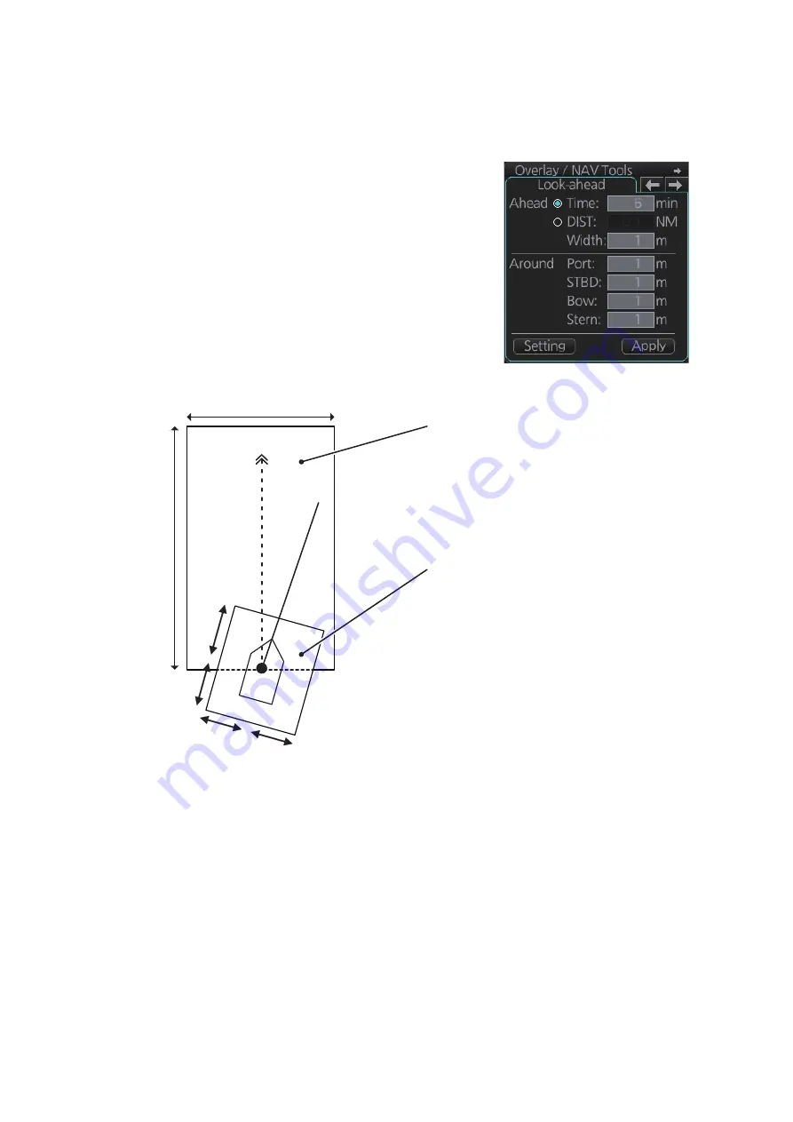
Calculation of own ship predicted movement area is done using a check area (two
places) about own ship position. Set the check area as follows:
1. Select the [Look-ahead] page from the [Overlay/
NAV Tools] box.
2. Referring to the figure below, set the ahead time
or distance and ahead width. Also, set the
"Around" figures: port, starboard, bow and stern
check distance.
The reference point is the conning position
(CCRP).
Both areas are shown as a thin black line one
screen.
3. To select the objects to use in chart alerts, click the [Chart Alert] button and see
4. Click the [Apply] button to affect the changes.
When an object set from the [Chart Alert] menu enters a set area, an alert is generated
in the following manner:
Objects or areas that generate an alert are shown in the following manner. (Alarms:
red highlight, Warnings/Cautions: yellow outline)
• Alarm or Warning level alerts: Alert message and aural alert are generated.
• Caution level alerts: Alert message is generated (no aural alert).
• Individual objects: The object is highlighted in red or outlined in yellow.
• Area objects: If the area object is larger than the look-ahead area, the look-ahead
area is highlighted in red or outlined in yellow. If the area object is smaller than the
look-ahead area, the area object is highlighted in red or outlined in yellow.
Width
Distance
Bow
Bow
Stern
Port
Starboard
Ahead
: Sets an area with a length
based on own speed (Time) or
distance (DIST) ahead of your ship.
The [Width] setting is applied to
either [Time] or [DIST], depending on
your selection. The area set here is
always oriented based on your
course (COG).
Around
: Sets a fixed area around
your ship. This area moves with your
ship, in relation to your current
heading (HDG).
Course
Course
Heading
Heading
Summary of Contents for FCR-2119-BB
Page 66: ...1 OPERATIONAL OVERVIEW 1 40 This page is intentionally left blank ...
Page 134: ...2 RADAR CHART RADAR OPERATION 2 68 This page is intentionally left blank ...
Page 182: ...4 AIS OPERATION 4 22 This page is intentionally left blank ...
Page 198: ...5 RADAR MAP AND TRACK 5 16 This page is intentionally left blank ...
Page 290: ...9 VECTOR S57 CHARTS 9 12 This page is intentionally left blank ...
Page 296: ...10 C MAP CHARTS 10 6 This page is intentionally left blank ...
Page 392: ...16 NAVIGATION SENSORS 16 16 This page is intentionally left blank ...
Page 398: ...17 AIS SAFETY NAVTEX MESSAGES 17 6 This page is intentionally left blank ...
Page 466: ...24 CONNING DISPLAYS 24 4 Example 2 General navigation Example 3 General navigation ...
Page 467: ...24 CONNING DISPLAYS 24 5 Example 4 General navigation Example 5 All waters navigation Silence ...
Page 534: ...FURUNO FCR 21x9 BB FCR 28x9 SERIES SP 6 E3607S01D M This page is intentionally left blank ...
Page 541: ......


