


DeX Operations Manual V. 2.1
Page 38
the target altitude will be reached. This arc will span from about 20 degrees left to 20
degrees right of the aircraft.
Note:
The VNAV Arc is computed based on the running averages of many dynamic flight
variables, so it will jump around a bit at first, but if the aircraft maintains a steady climb or
descent, this arc will settle in to show clearly where the target altitude will be reached.
To set up a VNAV target altitude, enter the Flight Plan Manifest screen. Next, tap once
on the desired waypoint in the flight plan listing in this screen – this will highlight this
leg of the flight plan. Then tap the VNAV button at the bottom of the screen to call up
the TARGET ALTITUDE slider. Use the slider control and/or the scroll wheel on the
side of the DEX to enter and ‘fine tune’ the target altitude. You may also tap in the
altitude box and type in the altitude with the keyboard number pad if you wish. Tap OK
to set the target altitude, or DISABLE VNAV to shut off VNAV coaching.
Automatic VNAV:
When you set up a flight plan to an airport, VNAV is automatically
selected with a target altitude of the airport’s elevation plus 1000 feet. This will result
in arriving at the airport at approximately pattern altitude.
IMPORTANT:
Remember that VNAV is always based on GPS ALTITUDE, it does
not allow for any difference between GPS altitude and indicated altitude (which is what
Air Traffic Control expects everyone to be using). Also VNAV only works on the
NEXT waypoint in the flight plan. Thus if you have a target altitude to a distant
waypoint, and an intermediate waypoint is inserted between the distant waypoint and
the current position, VNAV coaching will not begin until the intermediate waypoint is
passed.
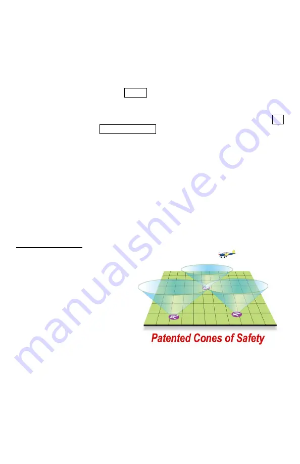
Cones of Safety®
Around every airport there is a
region of airspace, shaped like an
inverted cone, we call the “Cone of
Safety”. If the aircraft is inside of
this cone, it could glide to the
airport if the engine were to fail,
assuming that the winds aloft were
inconsequential. The cone gets
larger as the altitude above the
airport increases, and the radius of
the cone gets smaller as the surface
of the airport is approached.
Anywhere Map shows the cross section of these cones at the current aircraft altitude,
computing the altitude above the airport from the GPS derived altitude, and the airport
elevation. These cross sections are shown on the map a light green circles around each
airport. The higher the aircraft is above the airport, the larger the circle becomes.
The Cone of Safety display on the map screen allows the pilot to easily assess the glide-
friendliness of any flight by graphically showing the proportion of the flight path that is
inside or outside of the cones. As the cruising altitude increases, the cones often grow


