


S76G/S78G Commands Set Reference
v1.6.5
July 2, 2018
54 of 73
Product Name
Version
Doc No
Date
Page
b)
North or South:
Bit31 is fixed at
1
, Bit30 indicates it’s showing North or South (
1
: N, 0: S).
c)
Calculate Latitude as DD (decimal degree) format.
So change Bit31 & Bit30 as 0
“
00
00 1110 1010 1000 1001 1011 1100 0110”
0x
c
ea89bc6 becomes 0x
0
ea89bc6, and its decimal value is 245930950
245930950 / 10^7 = 24 (deg)
245930950 Modulo 10^7 = 5930950, 5930950 / 100000 = 59.30950 (minute)
59.30950 (minute) / 60 = 0.988492 (deg)
So the latitude is
North
,
24.988492
(deg), and it’s showing by DD format.
3.
Calculate Latitude: (e.g.
625b3bc8
, 0x62 is 8
th
bytes of the payload, 0xc8 is 11
th
)
a)
Change endian as below:
c8 3b 5b 62
0xc83b5b62 (hex)
“
1
100 1000 0011 1011 0101 1011 0110 0010”
b)
East or West:
Bit31 indicates it’s showing East or West (
1
: E, 0: W).
c)
Calculate Latitude as DD (decimal degree) format.
So change Bit31 & Bit30 as 0
“
00
00 1110 1010 1000 1001 1011 1100 0110”
0x
c
83b5b62 becomes 0x
4
83b5b62, and its decimal value is 1211849570
1211849570 / 10^7 = 121 (deg)
1211849570 Modulo 10^7 = 1849570, 1849570 / 100000 = 18.49570 (minute)
18.49570 (minute) / 60 = 0.308261 (deg)
So the longitude is
East
,
121.308261
(deg), and it’s showing by DD format.
Example:
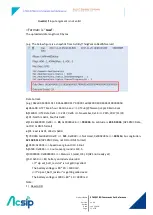
gps set_format_uplink utc_pos
>> Ok
3.3.5
gps set_positioning_cycle <Time>
<Time>: A decimal string representing the SONY CXD5603GF GPS positioning cycle time, it can be
1000
to
600000
milliseconds.
Response:
Ok
, if <Interval> string is valid.
Invalid
, if <Interval> string is not valid.
Purpose: Set a GPS cycle time that is used to tell how soon GPS will update its coordinates.
Example: